Artificial satellites orbiting high above the earth have revolutionized the fields of communications, meteorology, oceanology, geology, and ecology, among many others. Following the primitive Russian Sputnik 1 in 1957 and the U.S. 1958 Explorer 1, satellite design and instrumentation has improved at bewildering speeds. By taking advantage of advanced computer technology, ever smaller solid-state devices, and sophisticated electronic and optical technology, massive amounts of information are now available by satellite remote sensing of nearly any spot on earth. Some 3000 functioning artificial satellites owned by about 40 countries operate in various orbits and at various heights. They provide information useful for basic research, weather forecasting, communications, navigation, earth-observation, and military intelligence.
In proving the world's ecology and biosphere, earth-observation satellites provide pictures and high-resolution data at a scale as detailed as 1:50,000. Obtaining the output of these orbiting instruments, known as remote sensing, gives researchers much more information than would an astronaut looking down through high-power binoculars or a telescopic digital camera. Since earth-observation satellites contain multispectral sensors, or radiometers, investigators can examine a group of clearly defined light bands of reflected light, each capable of revealing specific processes on the earth’s surface or in its atmosphere. Moreover, some satellites are transmit radiation of their own, such as radar pulses, and record the reflected data to calculate the heights of the topography below. Radar is also useful for following the amount of dew and free vegetation water on various crops.
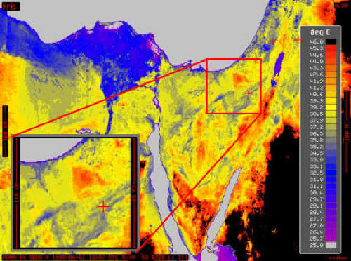 |
Thermal anomaly across the Israel-Egypt political border was observed in satellite images. This anomaly was explained by the different properties of the sand dunes of both sides of the border. While the Israeli side is covered by biogenic soil crust, the Egyptian side is characterized by bare sands. The biogenic soil crust consists mainly of cyanobacteria and particles of silt and clay and therefore is much darker than the dune sands. Consequently, the crust’s temperature was found to be considerably higher (up to 4°C) than the substrate bare sands.
Researchers at the Remote Sensing Laboratory (RSL) of the Blaustein Institutes for Desert Research develop sophisticated ways of using satellite data in probing vegetation in general and are applying these techniques to arid regions in particular. Their studies have measured the effects of drought on forests growing on the desert fringe , and they have designed techniques that predict – way before grains begin to develop – the likely yields of arid-zone wheat fields. These approaches can aid countries desiring to retard desertification by planting forests, as well as provide additional tools for expanding agriculture into low-precipitation regions. An RSL project in Mongolia has clarified the use of remote sensing in detecting plant health over a large multi-ecological expanse. Investigations of the soil surface of the Israeli Negev and bordering Sinai desert region in Egypt have revealed that the two have different ecosystems conditions, with different drought conditions despite similar precipitation levels.
