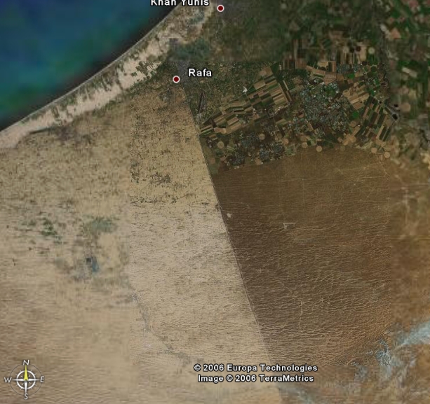
One of the sharpest demonstrations of the effect of human activity on ecosystem health is seen along the borderline demarcating the Israel-ruled Negev from the Egyptian-controlled Sinai. Despite their different geographic names, the climate, basic sand structures, and underlying geological formations of the adjacent Israeli and Egyptian areas are identical. However, early aerial photographs and satelliteimages clearly highlight the political borderline: the Egyptian side is much lighter and supports less vegetation than that of Israel. Desertification, in terms of shifting sand dunes in Egypt is therefore much more severe than in Israel.

|
Aerial photograph of the border between Israel and Egypt at the Northeren part of the Negev. The picture shows high contrast in albedo between the bright Sinai and the darker Negev.
Several researchers originally thought that
overgrazing of flocks – a well-recognized cause of desertification – was responsible for the high reflectivity of the Sinai soil. Sheep and goats of Bedouin herdsmen consume much of the available grasses and shrubs; the tribesmen too have a personal roll, by gathering plants that are useful for kindling. As a result, remote sensors recorded the reflectivity of vegetation-free areas of bare soil and sand. The Israeli side of the border, however, was declared a nature reserve, which is free of grazing.
Preliminary studies carried out by researchers at the
Remote Sensing Laboratory (RSL) of the Blaustein Institutes for Desert Research (BIDR) indicated that mere thinning of plants could not explain the great differences in ground reflectivity observed. In addition, grazing alone could not account for the
ecological disparity between the dunes on the Israeli side, which are fixed, and those in Egypt that shift like the sands of the Sahara.
| The dunes at the Israeli side of the border are fixed due to the biological soil crust while the dunes at Egyptian side are active. Photograped by Hezi Yizhaq. |
A closer examination by the BIDR remote-sensing team, headed by Prof. Arnon Karnieli showed that the most significant factor in creating the brightness differences is the disheveled Sinai soil surface produced by the trampling of animals and herdsmen. In theNegev, the soil remains unperturbed, allowing the growth of extremely delicate biological soil crusts, which are destroyed by flocks grazing on the other side of the border.
How, though, do these crusts help explain the different reflectivities? Cyanobacteria, formerly known as blue-green algae, and other living elements in these crusts absorb sunlight via pigments, such as green chlorophyll and blue phycocyanin. These compounds strongly reduce the light reflected by soil as compared to sandy ground that has lost its biological crust.
 |
Spectral characteristics of biogenic soil crusts can be similar to those of higher plants, especially when the crusts are wet. Therefore, in semi-arid environments, the reflectance of lower plant communities may lead to misinterpretation of the vegetation dynamics and overestimation of ecosystem productivity. |
In a study of remote-sensed AVHRR data recorded over four years from sites on both sides of the border, the RSL researchers were able to clearly demonstrate the severe desertification of the Egyptian Sinai. They measured the vegetation health as expressed by the normalized difference vegetation index (NDVI), along with land surface temperatures (LST) and precipitation. Their studies showed that in years of average precipitation the NDVI was significantly higher on the Israeli side due to the photosynthetic activity of the wet biological soil crusts. The Sinai, however, lack of biological soil crusts, shows very low NDVI values, similar to bare soils. Manipulating the data also revealed that while the Negev can exhibit a normal phenological cycle in a single year but Sinai no. Thus AVHRR imagery can provide valuable information for drought monitoring and characterization, as well as for detailing the effects and spread of desertification.
Previous section