The Central Asian sand seas: Linking geomorphology and palaeoclimate
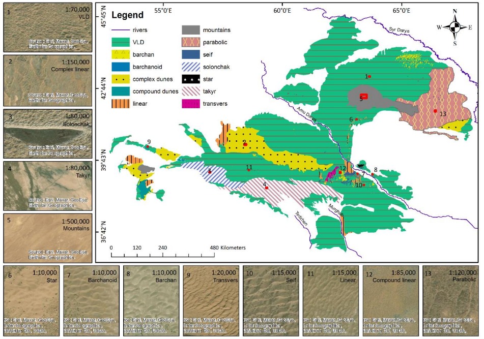
The Central Asian sand seas (ergs) are situated in the Turan basin, north-west of the Hindu Kush range and span from southern Turkmenistan to the Syr-Darya River in Kazakhstan. The Amu-Darya River dissects these ergs. To its north is the Kyzylkum (red sands) and to its south the Karakum (black sands). Combined, they form one of the largest sand seas in the world (over 500,000 km2). Though its vastness, this area is grossly understudied and only sparse information has been published regarding the sands' geomorphological evolution and related processes. There is also no published data of the depositional ages and chronology of the region. In contrast to previous research that classified these sand seas as active based solely on precipitation, our previously published remote sensing mapping results show that they are, in fact, mostly stabilized (~95%). Meteorological analysis of wind and precipitation data indicate a low wind energy environment (DP<200) and sufficient rainfall (>100 mm) to support vegetation. However, these classification and mapping results are only partial as they display a broad-scale classification describing only the dynamic state of the dunes (active or stabilized). Moreover, in recent years, luminescence dating techniques have become more accessible, widespread, and sufficiently accurate to support studies of climate change. Optically stimulated luminescence (OSL) is used to determine the time elapsed since quartz grains were last exposed to sunlight, hence indicating sand deposition. Many sand seas have been dated extensively by luminescence, e.g., the Kalahari, Namib, Australian linear dunes, and the northwestern Negev dune field in Israel. Apart from three ages published by the PI's, however, no other ages have thus far been published on the central Asian sand seas. The lack of published dune stratigraphy and numerical ages precludes reliable assessments of the paleoclimatic significance of the Central Asian dunes.In this proposal, we aim to investigate the current landscape, geomorphology, and evolution of the aeolian dune forms in the area using a variety of spaceborne imagery with varying spectral, temporal, and spatial resolutions. Satellite images will provide the basis for mapping the sand distribution, dune morphologies, and vegetation cover. The outcome of this state-of-the-art geomorphological map, will further serve as a base map to allocate potential sampling sites for field investigations that will enable us to reconstruct an OSL dating chronology and link it to changing climatic and geochemical/mineralogical factors. The OSL dates that will be obtained in this study will facilitate our understanding of the effects that climatic changes have had on the mobility and stability of the central Asian sand seas. Such comprehensive analysis will solidify our hypotheses regarding the Kyzylkum and Karakum sand seas dynamics, provide insights into past climate characteristics, and emphasize the importance of regional climatic control on aeolian activity.