Integrating Data from Various Sensors for Damage Assessment After a Natural Disaster in Rural Areas
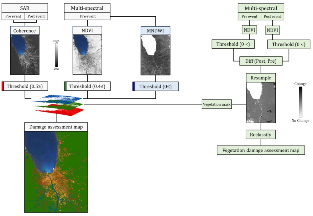
Remote sensing is a highly valuable tool in emergency situations, utilizing satellite imaging. These provide information that enables the detection, identification, monitoring, and mapping of changes before and after a disaster in a given geographic area, with high accuracy and extensive spatial coverage, as well as relatively low cost for damage assessment. Most current studies focus on post-disaster damage assessment by mapping damaged structures only in urban areas. However, studies addressing the extent or scope of damage in rural (non-urban) settlements are very few. Since almost half of the world's population lives in rural areas, and the existing services as well as their capabilities for post-disaster rescue are limited, it is crucial to assess the damage in these areas to enable appropriate preparedness. The goal and uniqueness of this research are to map, characterize, and assess the level and extent of damage, in physical terms, in rural and urban settlement areas after a multi-disaster event, an earthquake, and subsequent secondary disasters (tsunami, landslides, soil liquefaction, soil erosion, etc.). The immediate-term damage mapping, characterization, and assessment were carried out by integrating remote sensing data from various sensors with different resolution characteristics (temporal, spatial, and spectral). Data from optical sensors were combined with radar (SAR) data to produce maps that display the quantitative and spatial damage levels in built-up areas and vegetation zones (vegetation, agriculture). The obtained damage information is comprehensive and highly reliable. Using these maps allows for a rapid and tailored response by rescue teams on the ground to affected populated areas and for assessing the region's recovery after the disaster event.